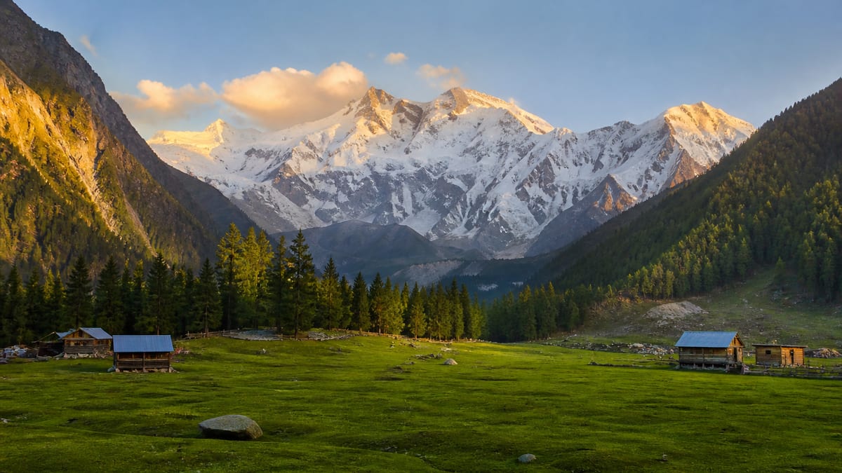
Diamer is one of the ten administrative districts of Gilgit-Baltistan. One tourist place is attached to it: Fairy Meadows. The visit built around that meadow is Diamer. The district boundary stays around that single name.
High passes and valley seasons for the region are on Climate and best time to visit Gilgit-Baltistan. Headquarters is Chilas, which that guide treats as the warmer lower-Indus town. Use the guide for those windows, and use the destination page when you are timing a Fairy Meadows day. One named place can still be a whole district trip if you plan it carefully.
Where Diamer sits
Diamer covers 7,234 square kilometres, with headquarters at Chilas. It is divided into five tehsils, and the 2023 population is 337,329, the largest population among these eight districts. Chilas is also the warmer lower-Indus town in the climate guide, at about 1,265 metres, with July around 28.2°C and January around 5.6°C. The headquarters town and Fairy Meadows are therefore not the same kind of day, even though both belong to this district’s geography.
The Karakoram Highway passes through the district, and through Chilas, so the headquarters is a road town as well as the civil centre. Above that road the ground changes quickly. Roughly 23 percent of Diamer is alpine pasture, and more than 53 percent of the remaining area is barren or permanently under snow. Fairy Meadows is the named place in that high country. The 2023 population of 337,329 belongs to the whole 7,234 square kilometres and its five tehsils, not to the meadow alone. Those tehsil names are not on the place list.
On the place list, Diamer is the Fairy Meadows district. It is not a long chain of named valleys, forts, or lakes. Travellers often arrive expecting a wider circuit. The record does not support that circuit. If a viewpoint is not Fairy Meadows, it is not a Diamer place until some later record says so.
Mountain records are a separate list. Every peak in that list, including Nanga Parbat at 8,125 metres, is stored without a district. Do not read the height of Nanga Parbat as proof that the summit sits inside Diamer. The destination page already warns against that assumption. The district page repeats it because the empty district field on the peak is an administrative fact, not a travel tip.
| Record | What is named |
|---|---|
| Role | One of the ten administrative districts |
| Area | 7,234 km² |
| Headquarters | Chilas |
| Tehsils | 5 |
| Population (2023) | 337,329 |
| Named place | Fairy Meadows |
| Named property | None on the lodging list |
| Peaks | Recorded separately, with no district shown |
Fairy Meadows
Fairy Meadows is the named outing. That is the sentence the district can stand on. Meadow paths, camp names beyond this record, and the walk in from the road are the destination page’s subject, not a second geography invented here.
No hotel or guesthouse is named inside Diamer. Until a property is filed on the district, a Fairy Meadows day is an outing from somewhere else, most often planned with Gilgit as the overnight on Diamer. Gilgit itself is another district, with its own places and its own hotels. Do not copy those hotels onto Diamer because the road passes through them.
What is deliberately left off this district
Babusar Pass is a named pass, and it is not assigned to Diamer. The climate guide describes it as the link from the Kaghan Valley toward Chilas. Chilas is the district headquarters, so the road arrives at the headquarters town. Babusar itself is still not a Diamer place entry. The five tehsils are a count only. Their individual names are not in the place list, so they are not guessed here.
Set beside the other districts, Diamer is the most populous of the eight, ahead of Gilgit’s 324,552, and larger in area than Gilgit at 4,208 square kilometres and Nagar at 4,137. It is still smaller than Ghizer, which covers 12,381 square kilometres with 200,069 people. The useful contrast is inside Diamer itself. Chilas, at about 1,265 metres, is the headquarters climate, and Fairy Meadows is the only named high outing. Five tehsils share that range. A single meadow name does not describe the whole 7,234 square kilometres.
The same rule covers language, festivals, and history articles. None are tagged to Diamer. The cultural life of the district is not described by copying Shina from Gilgit or Balti from Ghanche.
How to use the destination page
Diamer holds the practical visit: when people try the meadow, what to ask an operator, and the fact that no hotel is named here yet. The climate guide holds the seasonal windows for the region, including Babusar’s usual months, without making Babusar a Diamer village. The district record holds one positive attachment, Fairy Meadows, and a clear refusal to attach the unassigned peaks.
Reading Diamer’s numbers as a traveller
The figures on this record are civil statistics, and each one tells a visitor something slightly different. The area, 7,234 square kilometres, describes how much ground the district administers, not how much of it a tourist will see. Most of that ground is either alpine pasture, at roughly 23 percent, or barren and snowbound land, which makes up more than half of what remains. A traveller on the Karakoram Highway sees a thin ribbon of it from the road.
The population figure works the same way. 337,329 people live across five tehsils, and almost none of that count is at the meadow. When a guide or a driver talks about “Diamer”, ask whether they mean the district, the headquarters town at Chilas, or the Fairy Meadows outing. The three are linked, but they are not the same plan.
Chilas as a planning point
Chilas appears on this record for two reasons: it is the headquarters, and it is the warmer lower-Indus town in the climate guide. At about 1,265 metres, with July near 28.2°C, it can feel like a different country from a meadow at about 3,300 metres. That gap shapes packing. Clothes that suit a hot afternoon on the highway will not suit an evening below Nanga Parbat’s north face, and the reverse is just as true.
Because the Karakoram Highway runs through Chilas, many travellers pass the town without stopping. If your plan involves a break there, treat it as a road stop on the district’s civil centre, not as a separate attraction. No Chilas place page is on the list, and none is invented here.
Building a Diamer day without padding it
An honest Diamer itinerary is short on names and long on logistics. A sensible outline looks like this:
- Decide the overnight first. No property is named inside Diamer, so the night before and the night after the meadow are usually somewhere else. Many journeys use Gilgit, which is a separate district with its own listings.
- Confirm the road and the walk. The Fairy Meadows page describes leaving the Karakoram Highway for the meadow. Ask a licensed operator how long each leg takes in your travel week.
- Check the season. The climate guide gives regional windows. Snow, rain and road work can all change a meadow day.
- Keep Babusar separate. If you arrive or leave over Babusar Pass, that is a road crossing with its own months, not a Diamer sight.
Written down, that plan looks thin. It is meant to. Diamer’s record is one place deep, and a trip that respects that tends to go more smoothly than one stuffed with guessed stops.
Questions worth asking before you book
- Which district will I sleep in each night, and is the property licensed?
- How long is the drive from my overnight to the road head for the meadow, in this month?
- Is the walk-in open, and what does the operator do if weather closes it?
- Does my plan rely on Babusar, and if so, is the pass open that week?
- Who do I call if something goes wrong? Tourist Police can be reached on 1422 inside Gilgit-Baltistan and 05811-930055 from outside.
None of those answers is published on this record, which is exactly why they belong on your list.
Respect on the road and at the meadow
Diamer is home to more people than any of the other eight districts on these pages, and the road through Chilas is a working highway for them. Drive patiently, dress modestly, and ask before photographing people or homes. At the meadow, carry rubbish back down and keep to marked paths. The district record names one place, and keeping it in good shape keeps it worth visiting.
Frequently asked questions
What place is named for Diamer District?
Fairy Meadows. It is the only tourist place attached to the district.
Is Nanga Parbat in Diamer District?
Nanga Parbat is recorded at 8,125 metres on the mountain list, and that list does not assign any peak to a district. Do not treat the summit as a Diamer place on the strength of the height alone.
Is Babusar Pass part of Diamer?
Babusar Pass is a named pass and is not assigned to Diamer. Its seasonal note lives on the climate guide.
Is there a hotel named for Diamer?
No hotel or guesthouse is named for the district. The destination page explains how people plan the Fairy Meadows outing around that gap.
Where should I plan the visit?
Use Diamer for the trip, and the climate guide for the regional season. The district record is where the named place is Fairy Meadows and nowhere else.
Where is the headquarters of Diamer?
Chilas. It sits on the Karakoram Highway and is described in the climate guide as the warmer lower-Indus town, at about 1,265 metres.
How large is Diamer District?
The record gives 7,234 square kilometres, divided into five tehsils.
How many people live in Diamer?
The 2023 population is 337,329, the largest of the eight districts covered on these pages.
Can I visit Fairy Meadows as a day trip?
That depends on where you sleep and the state of the road and walk-in. Ask a licensed operator for timings in your travel week.
Who do I contact in an emergency in Diamer?
Tourist Police can be reached on 1422 inside Gilgit-Baltistan and 05811-930055 from outside the region.