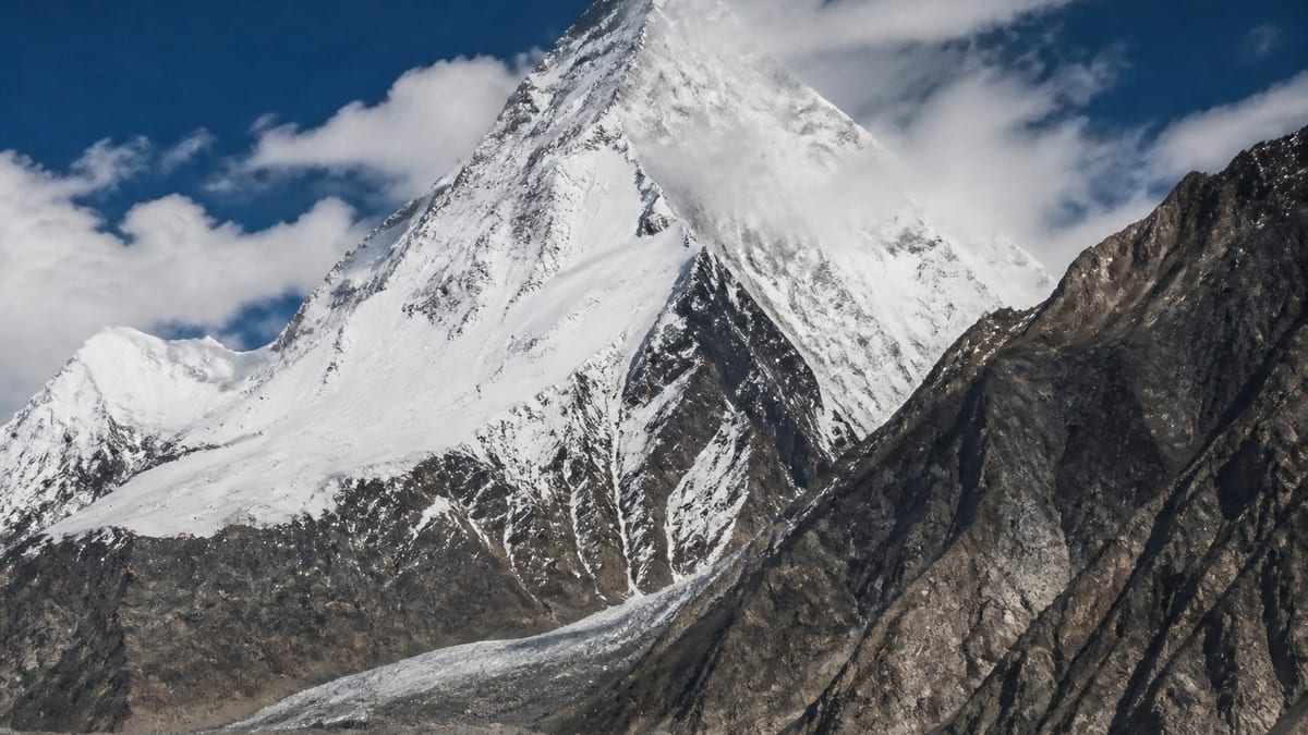
At 6590 metres on the official record, Makrong Chhish is one of the lower peaks on NADRA’s list, though it’s still high enough to demand a full expedition. The peak appears on the List of Peaks for Gilgit-Baltistan in the Pakistan Online Visa System (NADRA), which places it in the six-thousand-metre class. Because it’s listed, it comes under the national mountaineering permit framework, and anyone attempting it has to follow the registration and permit process of the Tourism Department and the Directorate of Tourist Services (DTS).
We’ve pulled together what the official record says about Makrong Chhish, flagged where it says nothing, and added the planning advice that applies to all of the region’s listed peaks. You won’t find routes, grades, first-ascent claims or operator recommendations, because the verified record contains none.
Makrong Chhish on paper
| Record | What is listed |
|---|---|
| Official list | NADRA List of Peaks (Gilgit-Baltistan) |
| Listed elevation | 6590 m |
| Height class | six-thousand-metre |
| District | Not assigned by the NADRA table |
| Coordinates | Not verified in the catalog |
| Routes and grades | Not published |
| Snapshot date | 2026-08-26 |
Pinning down the location
The NADRA peaks table leaves Makrong Chhish without an administrative district, and our catalog doesn’t have verified coordinates, so it isn’t on our map. All the record tells us is the regional picture: Gilgit-Baltistan is a mountainous area bordering Afghanistan, China and India, with some of the highest ranges on Earth. Get the exact location from your registered operator and the official permit documents; unverified maps aren’t a sound basis for planning.
How Makrong Chhish measures up
NADRA’s snapshot of 2026-08-26 gives Makrong Chhish an elevation of 6590 metres. Of the 104 NADRA-listed peaks in our catalog that state a height, 99 are listed higher and 4 lower, so it sits among the lower listed peaks. That’s a relative position only. Any peak at this altitude is a serious high-altitude objective. Since elevation figures can differ between sources and editions, confirm the current number against official publications before committing to an expedition.
Neighbours by height
Within roughly a hundred metres of Makrong Chhish’s 6590 m, the NADRA snapshot lists:
- Kuk Sar Peak – IV: 6566 m
- Savoia Kangri: 6550 m
- Yukshin Garden: 6500 m
A similar number on a list doesn’t make for a similar climb. Terrain, approach and conditions vary hugely from peak to peak, so use these only as reference points.
Conditions on the mountain
There’s no detailed terrain description for Makrong Chhish in our catalog. High peaks across Gilgit-Baltistan typically mix snow, ice, rock and glaciers, and the weather can change fast. Altitude, cold and remoteness add up, making even an objective that seems straightforward a real test. Be ready to rely on your own team’s resources, and plan for delays.
Permits: what’s required
The Tourism Department FAQ sets out the requirements: trekking and mountaineering registration, permits for restricted areas, and licensed guides and porters where mandated. The process involves:
- an online trekking or mountaineering application
- payment of royalty and environment fees
- insurance
- supporting documents, such as tour-operator application materials, a route map, passport copies and related receipts
We leave out fee amounts and form links because they change. The up-to-date process is in our guide to applying for trekking and mountaineering permits, with the underlying rules on the trekking and mountaineering regulations page.
Your support team
Registered tour operators on NADRA and DTS listings are the route the official FAQ describes. We don’t recommend a specific operator for Makrong Chhish. To vet one, use our hiring a tour operator guide; to understand guide licensing, see registering as a tour guide. Porter and mule hire is covered by Tourism Department and DTS guidelines, and terms should be agreed through your operator.
Picking a window
The catalog gives no climbing season for Makrong Chhish. Settle on timing with a licensed operator and follow official weather advisories, using our best time to visit Gilgit-Baltistan guide for regional seasons. Cold conditions are a given at any time of year, so pack warm clothing and sturdy footwear.
Routes into Gilgit-Baltistan
The region is normally reached via Gilgit Airport, Skardu International Airport, or road routes such as the Karakoram Highway. The approach to Makrong Chhish itself is specific to each expedition and isn’t part of the NADRA table. For the first leg, read getting to Gilgit-Baltistan and our Skardu International Airport page.
Packing list and money
From the department FAQ: warm clothes, sturdy shoes, sun protection, insect repellent, first-aid supplies, water and energy bars. Your operator will add the technical gear a peak like Makrong Chhish requires. Packing for Gilgit-Baltistan covers the basics in more depth. Carry enough cash, as the FAQ notes that the local currency is the Pakistani Rupee and credit cards aren’t widely accepted.
Risks to plan for
Altitude illness, crevasses, avalanches, rockfall and sudden weather changes are all genuine dangers on high peaks. Acclimatise gradually, keep your itinerary flexible, and turn back if conditions call for it. For road travel, advisories recommend experienced local drivers. Save these numbers from the Tourism Department FAQ: 1422 for the Tourist Police within Gilgit-Baltistan, and 05811-930055 when calling from outside GB.
Treading lightly
Carry out what you carry in and leave camps clean, as set out on our camping regulations page. Be respectful towards villages and porters on the approach, and observe the photography restrictions in border zones named in official material.
Making sense of the NADRA register
NADRA’s List of Peaks is an administrative tool. It shows that Makrong Chhish is recognised for permit purposes and records its elevation. It doesn’t tell you about routes, difficulty, history or access. Keep your sources in their lanes: the official list for permit status, your registered operator for logistics and route choice, and recent official advisories for conditions. Unverified details make their way into plans when those lines blur.
Names need care as well, since several listed peaks share a base name and differ only by a direction or number. Enter “Makrong Chhish” exactly as the official list spells it, so your permit matches your objective.
Steps to a Makrong Chhish expedition
Work through these in sequence:
- Confirm Makrong Chhish appears on the current NADRA list, and check its permit class.
- Engage a registered operator and agree the scope of support.
- Assemble passports, insurance, a route map and operator materials.
- Submit the online application and pay the current royalty and environment fees.
- Plan travel to Gilgit or Skardu with buffer days for flight or road delays.
- Arrange porters and mules through your operator under DTS guidelines.
- Agree an acclimatisation plan and a clear turnaround policy.
- Leave your itinerary and emergency contacts with someone at home.
Taking altitude slowly
Rushing is the enemy above 6,000 metres. Gain height bit by bit, schedule rest days, and keep watch for headache, nausea, breathlessness at rest or confusion, any of which can indicate altitude illness. When symptoms worsen, descent is the most reliable remedy. Decide ahead of time who can call a retreat on Makrong Chhish, so the choice isn’t improvised high on the mountain.
Insurance, comms and slack in the schedule
Insurance comes with the permit process, so read the policy closely: does it cover mountaineering at your planned altitude, and what happens if you need evacuating? Agree a communication plan, because mobile coverage in remote areas can’t be assumed. Build in spare days for weather and road delays. A plan that needs everything to go right isn’t a safe plan.
If you’ve time to spare
Some of your group might not be climbing, or you could have free days before or after Makrong Chhish. The department FAQ lists trekking, mountaineering, rock climbing, white-water rafting, paragliding, skiing, ski traversing and ice skating in Gilgit-Baltistan. Adventure sports operators, it says, must hold a Tourism Department licence, meet safety standards and provide trained, licensed guides. Water sports such as rafting and kayaking are regulated as well and require licensed guides.
Nearby places
No place record on our site currently links straight to Makrong Chhish. We add valleys and viewpoints as their own pages once sourced, so ask your operator which valleys you’ll pass through on the approach.
Outside this page’s scope
We don’t include:
- routes, grades or camp locations
- first-ascent or summit history
- fees, royalties or prices
- named operators, guides or lodges
- coordinates or district assignments not in the record
Putting this guide to work
Check Makrong Chhish’s listing and 6590 m elevation here, compare it with peaks of similar height, and follow the links to the permit process. For routes and logistics, your registered operator is the source.
Frequently asked questions
Is Makrong Chhish on NADRA’s peaks list?
Yes. It’s listed on the NADRA List of Peaks for Gilgit-Baltistan.
What is Makrong Chhish’s listed elevation?
6590 metres, per the NADRA snapshot of 2026-08-26.
Has Makrong Chhish been assigned a district?
No, the NADRA table doesn’t assign it to a district.
Do I need permission to climb Makrong Chhish?
Yes. You’ll need to complete the Tourism Department and DTS registration and permit process.
What should the permit file include?
The FAQ lists tour-operator application materials, a route map, passport copies, insurance and fee receipts.
Will I find climbing routes here?
No. Routes and grades are left out until verified records exist.
Is a licensed guide compulsory?
Licensed guides and porters are required where mandated. Ask your registered operator to confirm.
When can I climb Makrong Chhish?
The catalog gives no season, so plan with a licensed operator and official weather advisories.
What’s the usual way into Gilgit-Baltistan?
Gilgit Airport, Skardu International Airport or the Karakoram Highway.
Is there an emergency helpline?
Yes. Dial 1422 for the Tourist Police within Gilgit-Baltistan, or 05811-930055 from outside GB.
Source
List of Peaks (Gilgit-Baltistan) · Pakistan Online Visa System (NADRA) · Accessed 2026-08-26