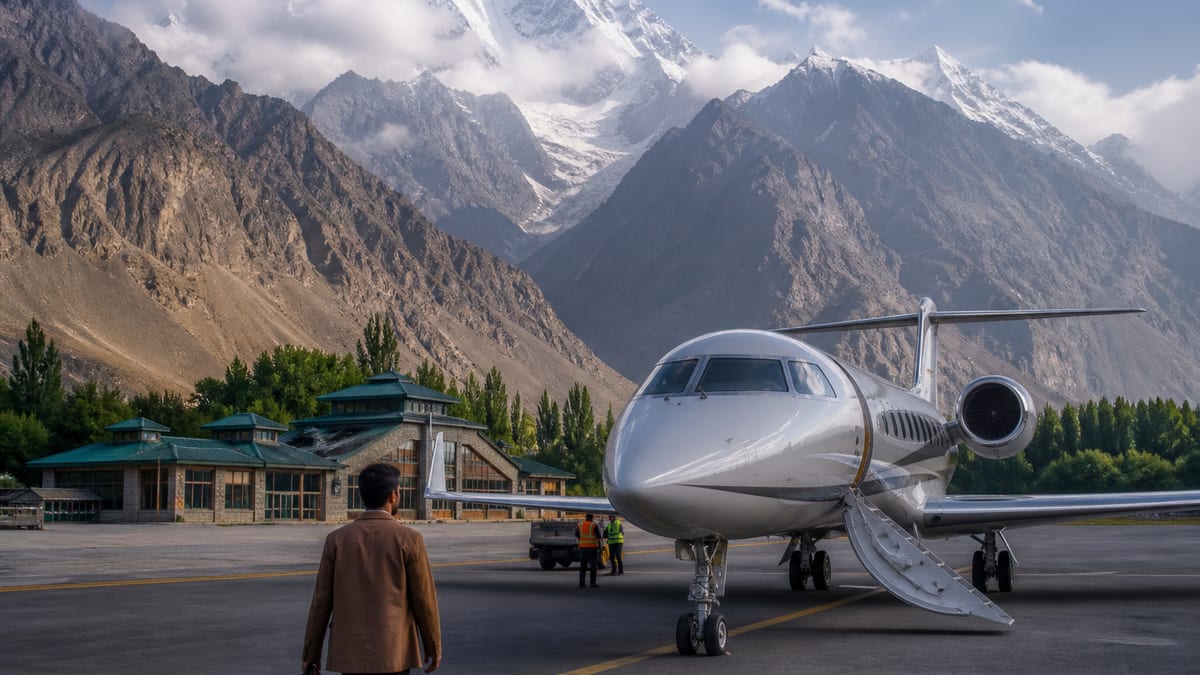
Skardu International Airport is one of the two airports the Gilgit-Baltistan tourism department names for the region. The other is Gilgit Airport. Skardu is the gateway for Baltistan: the town itself, the Kachura and Sadpara lakes, the Katpana cold desert, Shigar, Deosai National Park and the long approaches towards the Karakoram’s highest peaks. For many visitors, flying in saves a very long road journey and leaves more days for the mountains.
Mountain flying comes with conditions, though. This page explains how to reach Skardu by air and by road, what to expect on arrival, how to get from the airport to the places most people come to see, and how to plan around the weather. We don’t publish timetables or fares — they change constantly. Check with the airline before you book anything that depends on a flight.
The airport at a glance
Our Skardu destination page gives these details:
- Location: about 9.2 km from Skardu city, in Skardu Valley, where the Indus and Shigar rivers meet.
- Altitude: about 2,230 m at the airport. The town is at about 2,500 m.
- Status: the page describes it as the busiest airport in Gilgit-Baltistan, and says it became an international airport in December 2021.
- District: Skardu. Our Skardu district page calls Skardu the Baltistan district that holds the international airport.
The department’s FAQ, as recorded on our airports serving Gilgit-Baltistan page, names Skardu International Airport alongside Gilgit Airport as the region’s air access. Our source for this page is the FAQ “How can I travel to Gilgit-Baltistan?”
Reaching Skardu by air
Domestic flights
Our Skardu page says the flight from Islamabad takes about an hour to an hour and ten minutes, and names PIA and Airblue as the carriers on that route. It also mentions service from Lahore and other cities. Routes and frequencies change, so confirm with the airlines directly.
International access
Our Skardu page reports that PIA has run seasonal direct flights between Skardu and Dubai, first in August 2023 and again from May 2025. It advises checking whether that route is running before you plan around it. Most international visitors still connect through a larger Pakistani airport. If you’re coming from abroad, read hiring registered operators for international visits for the permit and operator side of the trip.
Why flights are cancelled
Our Skardu page explains that the approach is flown visually through the mountains, so cloud can ground flights — sometimes for days. Our airports guide makes the same point: weather, cloud cover and visibility affect mountain flights, and conditions can change quickly.
That leads to three rules of thumb from our pages:
- Leave two spare days at each end of a trip that depends on a Skardu flight.
- Don’t book an international connection within 72 hours of a Skardu flight.
- Keep a road back-up in mind, and book flexible nights in Skardu where you can.
Confirm your flight status before you leave for the airport, every time.
Reaching Skardu by road
From Islamabad
Our Skardu page describes the road route as up the Karakoram Highway to Jaglot, then onto the Jaglot–Skardu road through the Indus gorge. It puts the distance at about 635 km and 16–18 hours, with an overnight stop in Chilas or Gilgit. In summer, many people go via Naran and Babusar Top instead.
Our best time to visit guide says Babusar typically opens in late May or early June and closes in late October or November with the first heavy snowfall, and that it is for daylight travel only. Our Babusar Pass page calls June to September the reliable window. Don’t treat an opening date as fixed.
From Gilgit
Our Skardu page puts Gilgit to Skardu at four to five hours. That makes a Gilgit–Skardu combination practical, and our pages suggest flying into one and out of the other, with the road in between. See the Gilgit destination page.
Road safety on the Indus gorge
Our Skardu page describes the gorge as narrow, with rockfall zones, and advises driving it in daylight. You pass Raikot Bridge on the way — the turn-off for Fairy Meadows. Check travel alerts before you set off. The department’s advisory urges travellers in private vehicles to take precautions on narrow, winding mountain roads with landslide risk.
By bus
The FAQ says private companies and NATCO run daily buses from Rawalpindi and Islamabad to Gilgit and other districts; see NATCO and private bus access. Timetables and fares aren’t published here. The FAQ names the Karakoram Highway, Babusar Pass and Shandur Pass as the road approaches for personal transport; see road approaches.
Fly one way, drive the other
Our Skardu page notes that many travellers fly one way and drive the other. You see the Indus gorge, and you have a fall-back if a flight is cancelled.
From the airport: getting around Baltistan
Our getting to Gilgit-Baltistan guide says visitors arriving at Skardu can use the city as a base for Basho Valley, Upper Kachura Lake, Satpara Lake, the Katpana cold desert, Shigar Valley and other attractions. Here’s how the main ones sit relative to the airport and town, using our own place pages.
Katpana cold desert
Our Skardu page describes sand dunes at about 2,226 m near the airport, best at sunset. They make an easy first or last outing.
The Kachura lakes
Our Kachura Lake guide puts the two lakes about 25–30 km northwest of Skardu, beyond the airport, a 30–45 minute drive. It notes that the airport is closer to the lakes than the town is. Lower Kachura is also known as Shangrila Lake; see resorts.
Sadpara Lake and Deosai
Our Skardu page puts Sadpara Lake just south of town on the road up to Deosai. Deosai National Park is a full-day jeep trip via Sadpara and is usually open from June to mid-October. Our Deosai page says there’s no fuel, food or cash inside the park, so stock up in Skardu.
Shigar and beyond
Our Skardu page puts Shigar about 30 km away. Khaplu, Manthokha Waterfall in Kharmang and Basho Valley are further. Skardu is also the gateway to Askole and Hushe, the starting points for the Baltoro and K2 Base Camp. See Shigar Valley.
Taxis and transfers
Our Skardu page says it’s about 9 km from the airport to town. The FAQ says taxi and transport services need a licence from the Excise and Taxation Department and that drivers must hold a valid driving licence; see taxi and transport regulations. Our place pages advise agreeing every fare before you set off.
Planning around the seasons
Our Skardu page sketches the year like this:
- April–May: blossom in the villages, cool days and few crowds. The high plateaus are still snowbound.
- June–August: peak season. Deosai opens and trekking routes are busy, and hotels fill up.
- September–October: clear skies and golden poplars — the best balance of weather and quiet.
- November–March: severe cold, with roads and flights often disrupted. Only go if you’re prepared for winter conditions.
Our airports guide adds that you should book accommodation and transport ahead in the busy season, because Skardu and Hunza receive large numbers of visitors.
Health and paperwork on arrival
- Altitude: our Skardu page says the town rarely causes problems, but Deosai is above 4,000 m. Spend a night in town first.
- Permits: the same page says no permits are needed for the town and nearby sights. Treks and climbs towards K2 need separate permits; see applying for trekking and mountaineering permits.
- Cash: the FAQ says cards aren’t widely accepted; see local currency and cash.
- Language: our Skardu page says Balti is spoken and Urdu is widely understood; see Balti.
Skardu or Gilgit: which airport?
Our airports guide says Skardu is generally the better choice for Baltistan: Skardu, Shigar, Khaplu and the surrounding valleys. Gilgit is generally more suitable for Gilgit, Hunza, Nagar, Ghizer and nearby valleys. For a longer trip, you can arrive at one airport and leave from the other.
Where to stay near the airport
Our directory lists these Skardu District names from department lodging materials: Dewanekhas Hotel & Restaurant Skardu, Mashabrum Hotel Skardu, Mountain Lodge Skardu and Shangrila Resort Skardu. The listings give names and the district only. Ask each property how far it is from the airport and whether it can help if your flight is cancelled. See the Where to stay hub.
Frequently asked questions
Where is Skardu International Airport?
About 9.2 km from Skardu city in Skardu District, according to our Skardu page. It sits at about 2,230 m.
How long is the flight from Islamabad to Skardu?
About an hour to an hour and ten minutes, according to our Skardu page. Confirm schedules with the airline.
Are Skardu flights often cancelled?
Yes. The approach is flown visually, and cloud can ground flights — sometimes for days. Keep two spare days at each end.
Are there international flights to Skardu?
Our Skardu page reports seasonal direct PIA flights to Dubai in some years. Check whether the route is running before you plan around it.
How far is Skardu from Islamabad by road?
About 635 km and 16–18 hours via the Karakoram Highway and the Jaglot–Skardu road, with an overnight stop.
How long does it take to drive from Gilgit to Skardu?
About four to five hours, according to our Skardu page.
Which sights are closest to the airport?
The Katpana dunes are near the airport, and the Kachura lakes are beyond it, about 30–45 minutes from town.
Do I need a permit to visit Skardu?
Not for the town and nearby sights, according to our Skardu page. Treks and climbs towards K2 need separate permits.
When is the best time to fly to Skardu?
April to October. From November to March, roads and flights are often disrupted.
Should I fly into Skardu or Gilgit?
Skardu for Baltistan, Gilgit for Hunza, Nagar and Ghizer. Many travellers fly into one and out of the other.
—
Source: How can I travel to Gilgit-Baltistan? (Tourism Department FAQ), Tourism, Sports, Culture, Archaeology & Museums Department, Government of Gilgit-Baltistan. Accessed 27 August 2026. Airport, route, season and place details are from this site’s own destination, district, place, guide and knowledge pages. Confirm flights and road conditions before you travel.


